This site contains only a limited number of works of art sold in Australia and New Zealand, and is not representative of the art market for any artist. For a comprehensive art database visit our specialist site, Australian Art Sales Digest which includes over 400,000 works auctioned in Australia and New Zealand by over 30,000 artists, covering the period from the early 1970s to the present day.
John Tallis, Map of port Phillip and map of England and Wales
click the photo to enlarge
John Tallis, Map of port Phillip and map of England and Wales

You must be a subscriber, and be logged in to view price and dealer details.

Subscribe Now to view actual auction price for this item

When you subscribe, you have the option of setting the currency in which to display prices to $Au, $US, $NZ or Stg.

This item has been sold, and the description, image and price are for reference purposes only.

This item has been included into following indexes:

Visually similar items
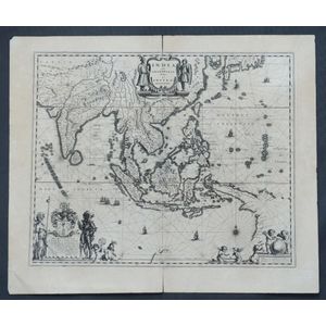
Map, India Quae Orientalis et Insulae Adiacinte. Mapmaker, Willem Janszoon Blaeu, c.1635. Engraving. 43 x 5 2 cm

Sold by in for
You can display prices in $Au, $US, $NZ or Stg.

The Royal Geographic Society silver world map, circa 1976, stamped 925/1000, with certificate and paperwork, 51 cm x 70 cm (frame)

Sold by in for
You can display prices in $Au, $US, $NZ or Stg.

H Yosmimoto, watercolour, bridge scene, signed lower right, 28 x 21 cm

Sold by in for
You can display prices in $Au, $US, $NZ or Stg.

1789 map 'A View of Lord Howe Island.' published July 31, 1789 by J. Stockdale. H& coloured engraving. 25 x 33 cm

Sold by in for
You can display prices in $Au, $US, $NZ or Stg.