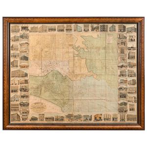
1872 Illustrated Map of Melbourne and Surrounding Businesses
'Illustrated Map of Melbourne and Suburbs Showing Government Sections and Allotments, Railways, Public Buildings, &c. Compiled from the latest Surveys and most authentic Sources to date. Published by Chas. F. Maxwell and W. Reed Phillips, 74 Chancery Lane Melbourne, 1872.' [Melbourne, Hamel & Ferguson Lith. 85 Queen St. Melbourne]; lithographed in sixteen sections and laid down on linen; each section being approx. 32 x 41 cm. Overall 1280 x 1610 cm; (framed 1420 mm x 1770 mm). Believed to Be Unique. The map is surrounded by 66 illustrations of the buildings or commercial premises occupied by the major businesses, banks and hotels to be found in Melbourne. The largest illustrations are for 'George Robertson Importer of Books and Stationery, and Account-Book Manufacturer' (centre left), 'The Carlton Brewery, Melbourne Edward Latham & Co.' (bottom centre) and 'Felton, Grimwade & Co., Wholesale Druggists' (centre right). Other businesses represented include 'Sands & McDougall's New Warehouses', 'Lawrence and Adam, Wholesale Grocers, Wine & Spirit Merchants', 'The Old White Hart Hotel', 'Brusher's Western Port Oyster Depot', 'W. Hutchinson's Iron Foundry', 'P. Falk & Co., Tobacco Merchants & General Importers', 'The Victoria Lime & Cement Company', 'W.H. Rocke & Co.'s Carpet and Furnishing Showrooms', 'James McEwan & Co. Wholesale Ironmongers & Iron Merchants', 'John Currie Wholesale Grocer and Wine Merchant', 'J. Beecher's Livery & Letting Stables' and 'Charles F. Maxwell, Law Bookseller & Publisher', and many more. A remarkable representation of the commercial and social life of Melbourne in the early 1870s.
You must be a subscriber, and be logged in to view price and dealer details.
Subscribe Now to view actual auction price for this item
When you subscribe, you have the option of setting the currency in which to display prices to $Au, $US, $NZ or Stg.
This item has been sold, and the description, image and price are for reference purposes only.
This item has been included into following indexes:
